AP-France German made
1. Weltkrieg > Luftbilder
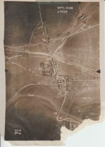
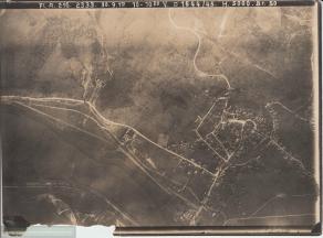
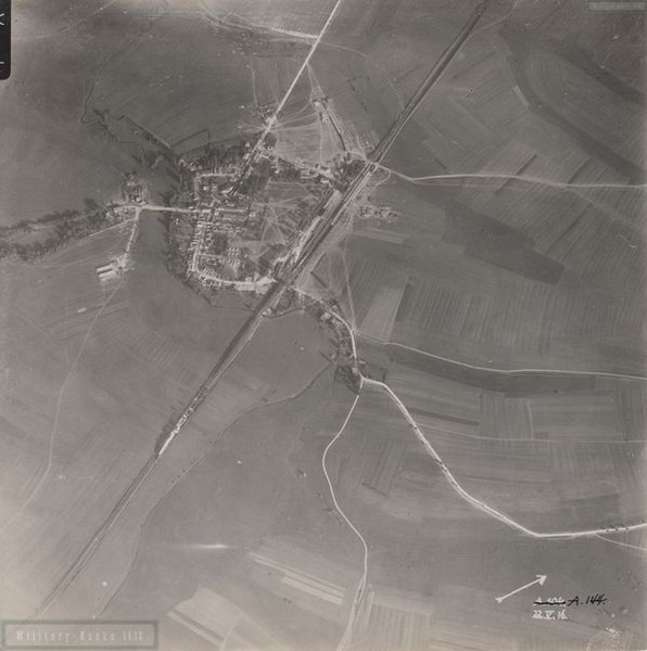
Aerial Photo Cuiry / Aisne
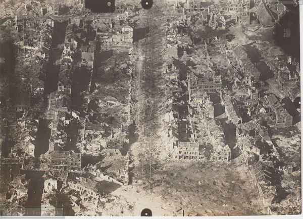
Map Section : 1963/1964
Flieger Abteilung : (A) 208
Date : 13.04.1917
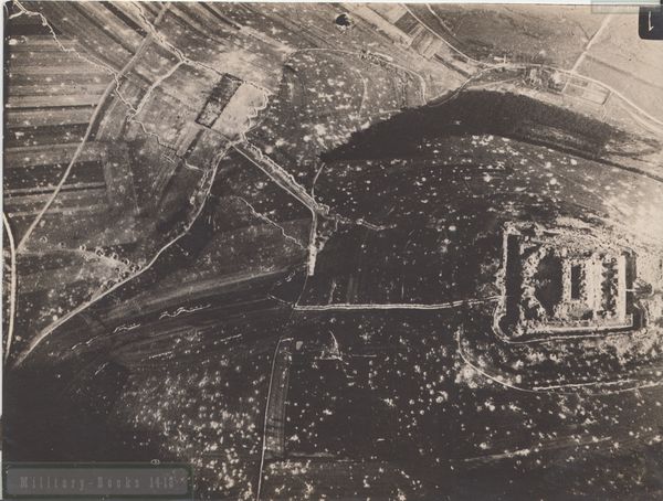
Picture shows : Cuiry village
You'll get a high resolution scan of the aerial photo including a Google Earth KMZ Overlay file positioning the photo in Google Earth !
Click on picture to see location of photograph !
Map Section : 1963/1964
Flieger Abteilung : (A) 208
Date : 13.04.1917
Picture shows : Cuiry village
You'll get a high resolution scan of the aerial photo including a Google Earth KMZ Overlay file positioning the photo in Google Earth !
Click on picture to see location of photograph !
1,50€
Hinzufügen
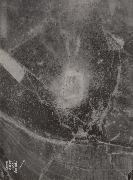
Aerial Photo La Bovelle Ferme / Aisne
Map Section : not provided
Flieger Abteilung : not provided
Date : unknown
Picture shows : Trenches around La Bovelle Ferme
You'll get a high resolution scan of the aerial photo including a Google Earth KMZ Overlay file positioning the photo in Google Earth !
Click on picture to see location of photograph !
1,50€
Hinzufügen
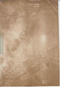
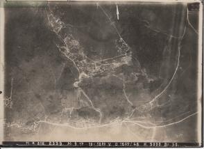
Aerial Photo Jumigny / Aisne
Map Section : 1660
Flieger Abteilung : (A) 208
Date : 13.04.1917
Picture shows : Jumigny and vincinity north of Jumigny, Trenches
You'll get a high resolution scan of the aerial photo including a Google Earth KMZ Overlay file positioning the photo in Google Earth !
Click on picture to see location of photograph !
1,50€
Hinzufügen
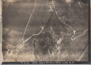
Aerial Photo Soupir / Aisne
Map Section : 1649/1650
Flieger Abteilung : (A) 216
Date : 22.09.1917
Picture shows : Vincinity northwest of Soupir, Trenches
You'll get a high resolution scan of the aerial photo including a Google Earth KMZ Overlay file positioning the photo in Google Earth !
Click on picture to see location of photograph !
1,50€
Hinzufügen
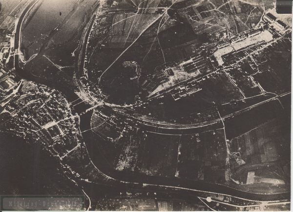
Aerial Photo Vailly / Aisne
Map Section : 1644/1645
Flieger Abteilung : (A) 216
Date : 30.09.1917
Picture shows : City Vailly-sur-Aisne and vincinity west
You'll get a high resolution scan of the aerial photo including a Google Earth KMZ Overlay file positioning the photo in Google Earth !
Click on picture to see location of photograph !
1,50€
Hinzufügen
Aerial Photo Vailly / Aisne
Map Section : 1647/1648
Flieger Abteilung : (A) 216
Date : 30.09.1917
Picture shows : Vincinity east of Vailly-sur-Aisne, Trenches
You'll get a high resolution scan of the aerial photo including a Google Earth KMZ Overlay file positioning the photo in Google Earth !
Click on picture to see location of photograph !
1,50€
Hinzufügen
Aerial Photo Gouzeaucourt / Somme
Map Section : 1948/1949/2048/2049/2147/2148
Flieger Abteilung : 202
Date : 12.03.1918
Picture shows : Vincinity south of Gouzeaucourt, Trenches
You'll get a high resolution scan of the aerial photo including a Google Earth KMZ Overlay file positioning the photo in Google Earth !
Click on picture to see location of photograph !
1,50€
Hinzufügen
Aerial Photo Vaueelette Ferme / Somme
Map Section : 2148/2248/2249
Flieger Abteilung : 202
Date : 11.03.1918
Picture shows : Vincinity southwest of Gouzeaucourt Vaueelette Ferme , Trenches
You'll get a high resolution scan of the aerial photo including a Google Earth KMZ Overlay file positioning the photo in Google Earth !
Click on picture to see location of photograph !
1,50€
Hinzufügen
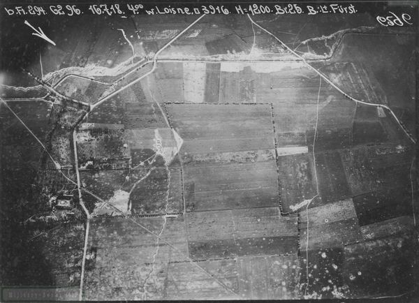
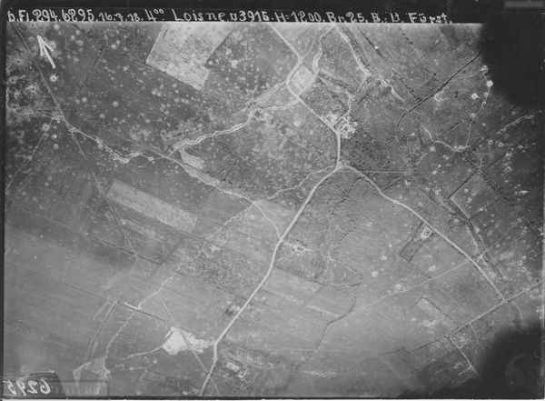
Aerial Photo Loisne
Map Section : 3916
Flieger Abteilung : 294
Date : 16.07.1918
Picture shows : Vincinity 2 km north of Le Quesnoy
You'll get a high resolution scan of the aerial photo including a Google Earth KMZ locator file showing the position in Google Earth !
Click on picture to see location of photograph !
Map Section : 3916
Flieger Abteilung : 294
Date : 16.07.1918
Picture shows : Vincinity 2 km north of Le Quesnoy
You'll get a high resolution scan of the aerial photo including a Google Earth KMZ locator file showing the position in Google Earth !
Click on picture to see location of photograph !
Sofort verfügbar
1,00€
Hinzufügen
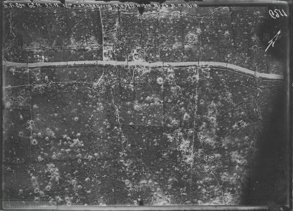
Aerial Photo Richebourg/Neuve Chapelle
Map Section : 3711
Flieger Abteilung : 294
Date : 09.07.1918
Picture shows : Vincinity west of todays Memorial Neuve Chapelle
You'll get a high resolution scan of the aerial photo including a Google Earth KMZ locator file showing the position in Google Earth !
Click on picture to see location of photograph !
Sofort verfügbar
1,00€
Hinzufügen
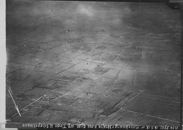
Aerial Photo Richebourg
Map Section : 3813
Flieger Abteilung : 14
Date : 19.05.1918
Picture shows : Vincinity west of todays Rue du Haut Chemin
You'll get a high resolution scan of the aerial photo including a Google Earth KMZ locator file showing the position in Google Earth !
Click on picture to see location of photograph !
Sofort verfügbar
1,00€
Hinzufügen
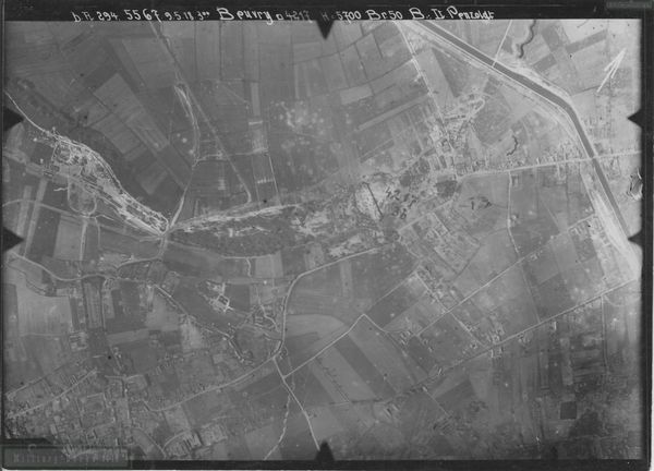
Aerial Photo Beuvry/Le Quesnoy
Map Section : 5567
Flieger Abteilung : 294
Date : 9.05.1918
Picture shows : Vincinity of Le Quesnoy north through Beuvry to Canal d'Aire
You'll get a high resolution scan of the aerial photo including a Google Earth KMZ locator file showing the position in Google Earth !
Click on picture to see location of photograph !
Sofort verfügbar
1,00€
Hinzufügen
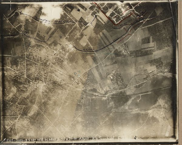
Aerial Photo Albert
Map Section : 3823
Flieger Abteilung : 227
Date : 2.05.1918
Picture shows : City of Albert and northern Vincinity
You'll get a high resolution scan of the aerial photo including a Google Earth KMZ locator file showing the position in Google Earth !
Click on picture to see location of photograph !
Map Section : 3823
Flieger Abteilung : 227
Date : 2.05.1918
Picture shows : City of Albert and northern Vincinity
You'll get a high resolution scan of the aerial photo including a Google Earth KMZ locator file showing the position in Google Earth !
Click on picture to see location of photograph !
Sofort verfügbar
1,00€
Hinzufügen
Aerial Photo Loisne
Map Section : 3916
Flieger Abteilung : 294
Date : 16.07.1918
Picture shows : Vincinity of road junction Rue de Loisne-Rue du Moulin and Rue du Pont de Loisne and Rue de Loisne north of Loisne
You'll get a high resolution scan of the aerial photo including a Google Earth KMZ locator file showing the position in Google Earth !
Click on picture to see location of photograph !
Sofort verfügbar
1,00€
Hinzufügen
Aerial Photo Han-sur-Meuse
Map Section : n.a.
Flieger Abteilung : n.a.
Date : n.a.
Picture shows : Vincinity north of Meuse/Han-sur-Meuse , road D964 towards Saint-Mihiel
You'll get a high resolution scan of the aerial photo including a Google Earth KMZ locator file showing the position in Google Earth !
Click on picture to see location of photograph !
Sofort verfügbar
1,00€
Hinzufügen
Aerial Photo Ailly-sur-Meuse
Map Section : n.a.
Flieger Abteilung : n.a.
Date : n.a.
Picture shows : Vincinity north of Meuse/Ailly-sur-Meuse , Route du bois d'ailly and road towards Saint-Mihiel
You'll get a high resolution scan of the aerial photo including a Google Earth KMZ locator file showing the position in Google Earth !
Click on picture to see location of photograph !
Sofort verfügbar
1,00€
Hinzufügen
Aerial Photo Fort du Camp Romains
Map Section : n.a.
Flieger Abteilung : n.a.
Date : n.a.
Picture shows : Fort du Camp Romains and vincinity east
You'll get a high resolution scan of the aerial photo including a Google Earth KMZ locator file showing the position in Google Earth !
Click on picture to see location of photograph !
Map Section : n.a.
Flieger Abteilung : n.a.
Date : n.a.
Picture shows : Fort du Camp Romains and vincinity east
You'll get a high resolution scan of the aerial photo including a Google Earth KMZ locator file showing the position in Google Earth !
Click on picture to see location of photograph !
Sofort verfügbar
1,00€
Hinzufügen
Aerial Photo Saint-Mihiel/Chauvoncourt
Map Section : n.a.
Flieger Abteilung : n.a.
Date : n.a.
Picture shows : Meuse between Saint-Mihiel and Chauvoncourt deep into Chauvoncourt
You'll get a high resolution scan of the aerial photo including a Google Earth KMZ locator file showing the position in Google Earth !
Click on picture to see location of photograph !
Sofort verfügbar
1,00€
Hinzufügen
Aerial Photo Lens
Map Section : n.a.
Flieger Abteilung : n.a.
Date : n.a.
Picture shows : Place Roger Salengro view from east to west
You'll get a high resolution scan of the aerial photo including a Google Earth KMZ locator file showing the position in Google Earth !
Click on picture to see location of photograph !
Map Section : n.a.
Flieger Abteilung : n.a.
Date : n.a.
Picture shows : Place Roger Salengro view from east to west
You'll get a high resolution scan of the aerial photo including a Google Earth KMZ locator file showing the position in Google Earth !
Click on picture to see location of photograph !
Sofort verfügbar
1,00€
Hinzufügen
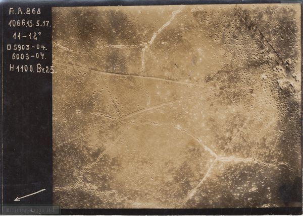
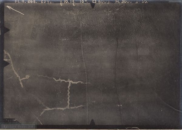
Aerial Photo Arleux-en-Gohelle
Map Section : 5903,5904,6003,6004
Flieger Abteilung : 268
Date : 15.05.1917
Picture shows : East end of Village and Roads heading north/northeast
You'll get a high resolution scan of the aerial photo including a Google Earth KMZ locator file showing the position in Google Earth !
Click on picture to see location of photograph !
Sofort verfügbar
1,00€
Hinzufügen
Aerial Photo Fresnoy-en-Gohelle
Map Section : 6003
Flieger Abteilung : 268
Date : 7.10.1917
Picture shows : Rue de Bois Bernard between Fresnoy-en-Gohelle and Arleux-en-Gohelle
You'll get a high resolution scan of the aerial photo including a Google Earth KMZ locator file showing the position in Google Earth !
Click on picture to see location of photograph !
Sofort verfügbar
1,00€
Hinzufügen
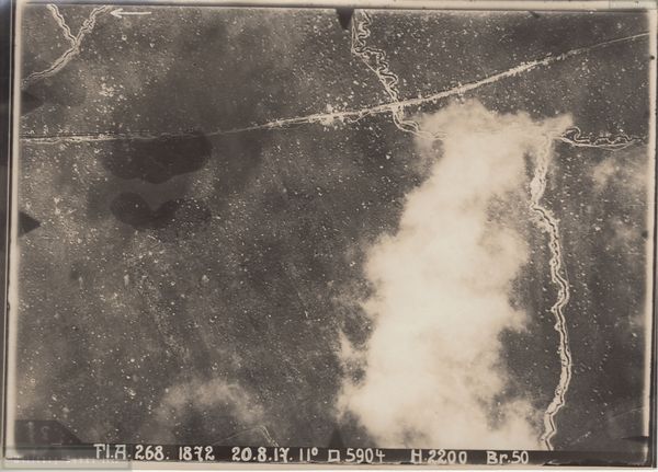
Aerial Photo Arleux-en-Gohelle
Map Section : 5904
Flieger Abteilung : 268
Date : 20.08.1917
Picture shows : Vincinity 1 km north of Arleux-en-Gohelle Road heading north
You'll get a high resolution scan of the aerial photo including a Google Earth KMZ locator file showing the position in Google Earth !
Click on picture to see location of photograph !
Sofort verfügbar
1,00€
Hinzufügen
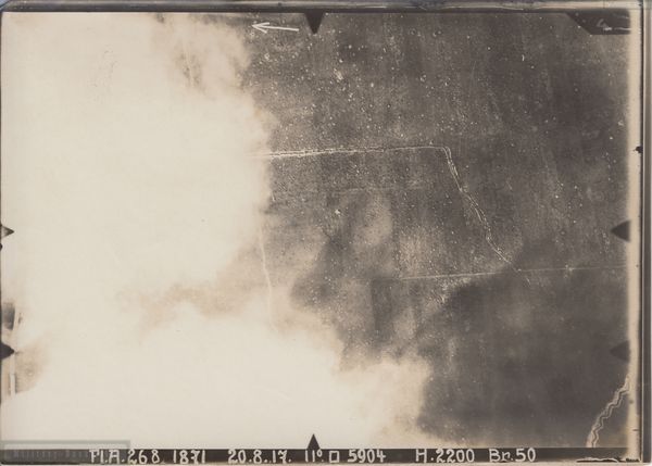
Aerial Photo Arleux-en-Gohelle
Map Section : 5904
Flieger Abteilung : 268
Date : 20.08.1917
Picture shows : Vincinity 1 km north of Arleux-en-Gohelle Road heading northnortheast
You'll get a high resolution scan of the aerial photo including a Google Earth KMZ locator file showing the position in Google Earth !
Click on picture to see location of photograph !
Sofort verfügbar
1,00€
Hinzufügen
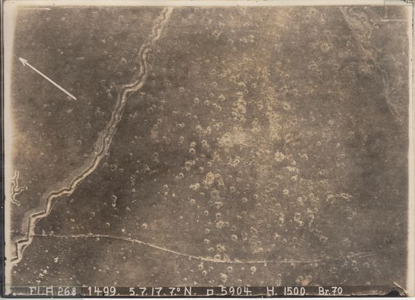
Aerial Photo Arleux-en-Gohelle
Map Section : 5904
Flieger Abteilung : 268
Date : 05.07.1917
Picture shows : Vincinity 0,5 km north of Arleux-en-Gohelle Road heading northnortheast
You'll get a high resolution scan of the aerial photo including a Google Earth KMZ locator file showing the position in Google Earth !
Click on picture to see location of photograph !
Sofort verfügbar
1,00€
Hinzufügen
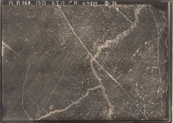
Aerial Photo Arleux-en-Gohelle
Map Section : 4800 (5903 is actual better description, proof comparison to other pictures)
Flieger Abteilung : 268
Date : 6.07.1917
Picture shows : Vincinity 1 km north of Arleux-en-Gohelle Road heading north
You'll get a high resolution scan of the aerial photo including a Google Earth KMZ locator file showing the position in Google Earth !
Click on picture to see location of photograph !
Sofort verfügbar
1,00€
Hinzufügen
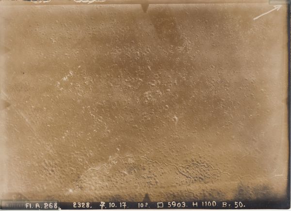
Aerial Photo Fresnoy-en-Gohelle
Map Section : 5903
Flieger Abteilung : 268
Date : 7.10.1917
Picture shows : Vincinity 1 km north of Fresnoy-en-Gohelle
You'll get a high resolution scan of the aerial photo including a Google Earth KMZ locator file showing the position in Google Earth !
Click on picture to see location of photograph !
Sofort verfügbar
1,00€
Hinzufügen
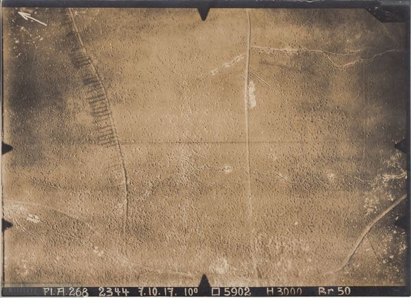
Aerial Photo Fresnoy-en-Gohelle
Map Section : 5902
Flieger Abteilung : 268
Date : 7.10.1917
Picture shows : Road section junction Rue d'acheville / D919 and eastern Vincinity including Rue de Bois Bernard in Fresnoy-en-Gohelle
You'll get a high resolution scan of the aerial photo including a Google Earth KMZ locator file showing the position in Google Earth !
Click on picture to see location of photograph !
Sofort verfügbar
1,00€
Hinzufügen
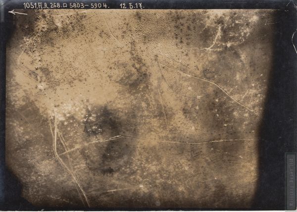
Aerial Photo Fresnoy-en-Gohelle
Map Section : 5803,5904
Flieger Abteilung : 268
Date : 12.05.1917
Picture shows : Road north of Fresnoy-en-Gohelle that links Arleux-en-Gohelle to Acheville
You'll get a high resolution scan of the aerial photo including a Google Earth KMZ locator file showing the position in Google Earth !
Click on picture to see location of photograph !
Sofort verfügbar
1,00€
Hinzufügen
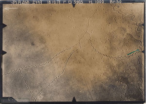
Aerial Photo Arleux-en-Gohelle
Map Section : 5903
Flieger Abteilung : 268
Date : 18.10.1917
Picture shows : Vincinity 1,5 km north of Arleux-en-Gohelle Road heading northnortheast
You'll get a high resolution scan of the aerial photo including a Google Earth KMZ locator file showing the position in Google Earth !
Click on picture to see location of photograph !
Sofort verfügbar
1,00€
Hinzufügen
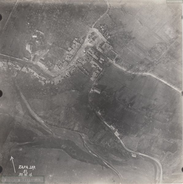
Aerial Photo Watronville
Map Section : n.a.
Flieger Abteilung : 207
Date : 30.03.1916
Picture shows : Village of Watronville
You'll get a high resolution scan of the aerial photo including a Google Earth KMZ locator file showing the position in Google Earth !
Click on picture to see location of photograph !
Map Section : n.a.
Flieger Abteilung : 207
Date : 30.03.1916
Picture shows : Village of Watronville
You'll get a high resolution scan of the aerial photo including a Google Earth KMZ locator file showing the position in Google Earth !
Click on picture to see location of photograph !
Sofort verfügbar
1,00€
Hinzufügen
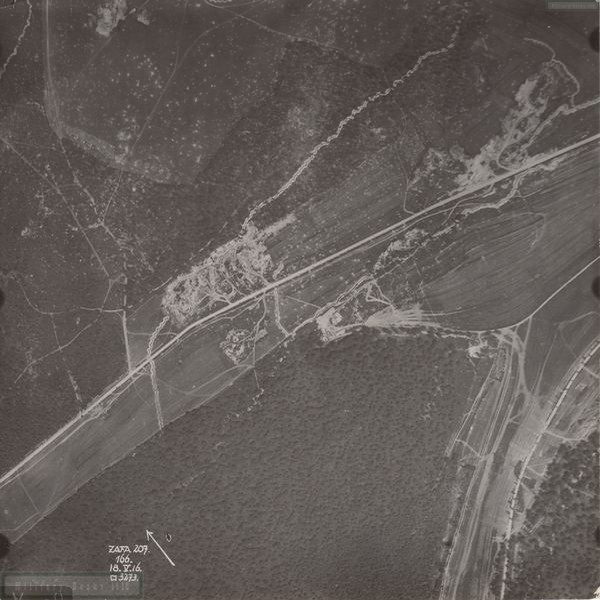
Aerial Photo Haudiomont
Map Section : 3273
Flieger Abteilung : 207
Date : 18.05.1916
Picture shows : Vincinity 1,5 km west of Haudiomont along D903
You'll get a high resolution scan of the aerial photo including a Google Earth KMZ locator file showing the position in Google Earth !
Click on picture to see location of photograph !
Sofort verfügbar
1,00€
Hinzufügen
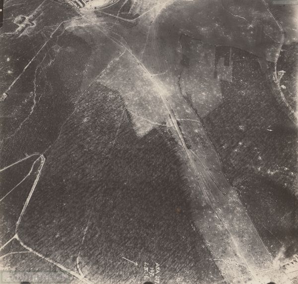
Aerial Photo Fleury - Fort Vaux
Map Section : n.a.
Flieger Abteilung : 207
Date : 02.04.1916
Picture shows : Vincinity 1,5 km southwest of Fort Vaux and 1,5 km southeast of Fleury
You'll get a high resolution scan of the aerial photo including a Google Earth KMZ locator file showing the position in Google Earth !
Click on picture to see location of photograph !
Sofort verfügbar
1,00€
Hinzufügen
Aerial Photo Spincourt
Map Section : n.a.
Flieger Abteilung : n.a.
Date : 22.05.1916
Picture shows : Village de Spincourt
You'll get a high resolution scan of the aerial photo including a Google Earth KMZ locator file showing the position in Google Earth !
Click on picture to see location of photograph !
Map Section : n.a.
Flieger Abteilung : n.a.
Date : 22.05.1916
Picture shows : Village de Spincourt
You'll get a high resolution scan of the aerial photo including a Google Earth KMZ locator file showing the position in Google Earth !
Click on picture to see location of photograph !
Sofort verfügbar
1,00€
Hinzufügen
Aerial Photo Ouvrage de la Lauffee
Map Section : 2569
Flieger Abteilung : 207
Date : 23.06.1916
Picture shows : Ouvrage de la Lauffee
You'll get a high resolution scan of the aerial photo including a Google Earth KMZ locator file showing the position in Google Earth !
Click on picture to see location of photograph !
Map Section : 2569
Flieger Abteilung : 207
Date : 23.06.1916
Picture shows : Ouvrage de la Lauffee
You'll get a high resolution scan of the aerial photo including a Google Earth KMZ locator file showing the position in Google Earth !
Click on picture to see location of photograph !
Sofort verfügbar
1,00€
Hinzufügen
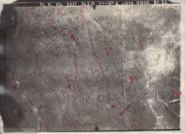
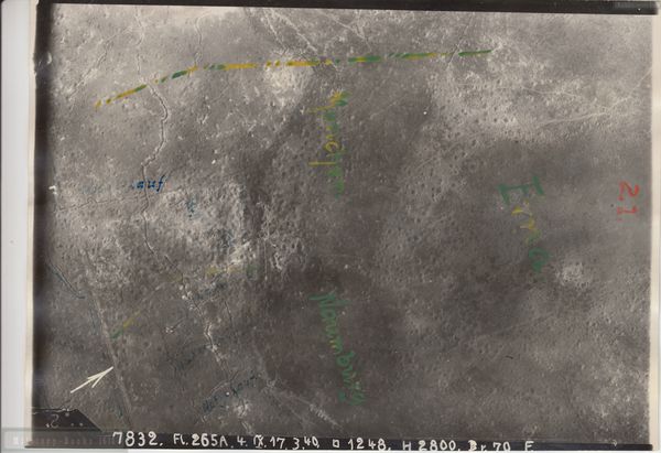
Aerial Photo Chemin de Dames La Royere
Map Section : 1248
Flieger Abteilung : 216
Date : 26.08.1917
Picture shows : Ferme La Royere and Trenches south
You'll get a high resolution scan of the aerial photo including a Google Earth KMZ locator file showing the position in Google Earth !
Click on picture to see location of photograph !
Map Section : 1248
Flieger Abteilung : 216
Date : 26.08.1917
Picture shows : Ferme La Royere and Trenches south
You'll get a high resolution scan of the aerial photo including a Google Earth KMZ locator file showing the position in Google Earth !
Click on picture to see location of photograph !
Sofort verfügbar
1,00€
Hinzufügen
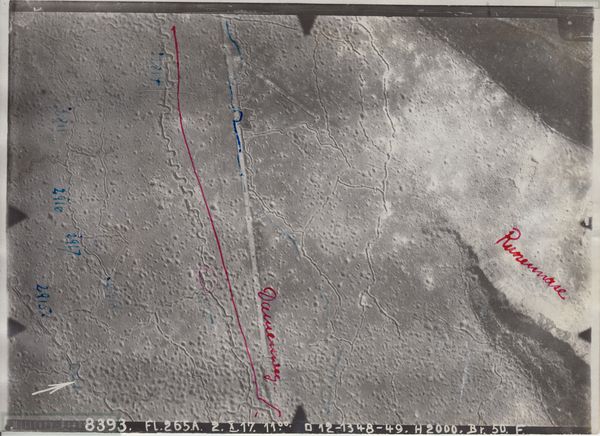
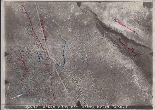
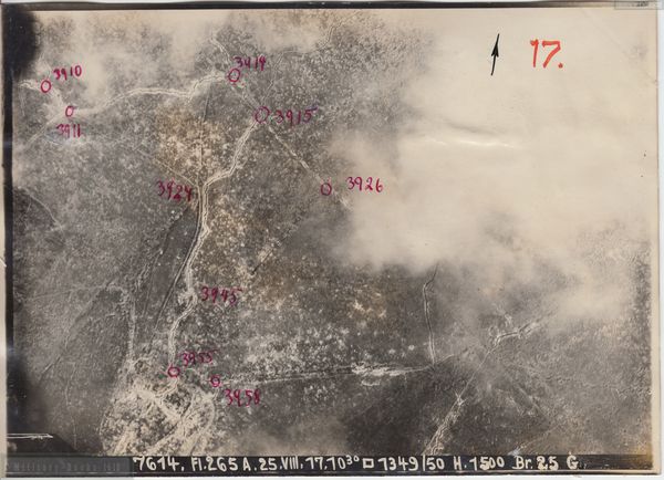
Aerial Photo Chemin de Dames La Royere Russennase
Map Section : 1248,1348
Flieger Abteilung : 265A
Date : 02.10.1917
Picture shows : Vincinity 500 east of Ferme La Royere and Vincinity of Russennase
You'll get a high resolution scan of the aerial photo including a Google Earth KMZ locator file showing the position in Google Earth !
Click on picture to see location of photograph !
Sofort verfügbar
1,00€
Hinzufügen
Aerial Photo Chemin de Dames La Royere
Map Section : 1248
Flieger Abteilung : 265A
Date : 11.09.1917
Picture shows : Ferme La Royere
You'll get a high resolution scan of the aerial photo including a Google Earth KMZ locator file showing the position in Google Earth !
Click on picture to see location of photograph !
Map Section : 1248
Flieger Abteilung : 265A
Date : 11.09.1917
Picture shows : Ferme La Royere
You'll get a high resolution scan of the aerial photo including a Google Earth KMZ locator file showing the position in Google Earth !
Click on picture to see location of photograph !
Sofort verfügbar
1,00€
Hinzufügen
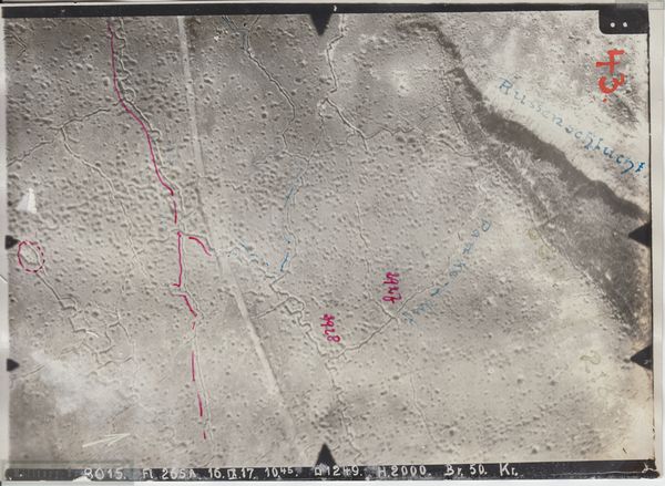
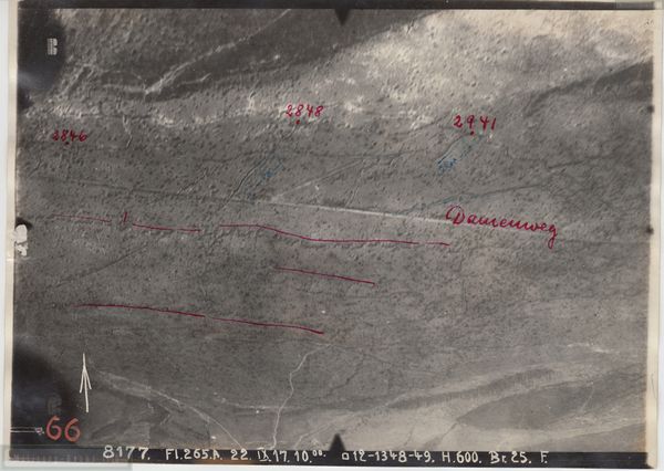
Aerial Photo Chemin de Dames La Royere Russennase
Map Section : 1249
Flieger Abteilung : 265A
Date : 02.10.1917
Picture shows : Vincinity 1 km east of Ferme La Royere and Vincinity of Russennase
You'll get a high resolution scan of the aerial photo including a Google Earth KMZ locator file showing the position in Google Earth !
Click on picture to see location of photograph !
Sofort verfügbar
1,00€
Hinzufügen
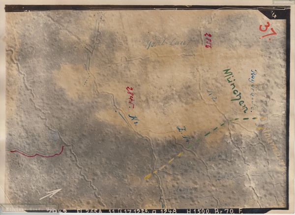
Aerial Photo Chemin de Dames La Royere Russennase
Map Section : 1249
Flieger Abteilung : 265A
Date : 16.09.1917
Picture shows : Vincinity 1 km east of Ferme La Royere and Vincinity of Russennase/Russenschlucht
You'll get a high resolution scan of the aerial photo including a Google Earth KMZ locator file showing the position in Google Earth !
Click on picture to see location of photograph !
Sofort verfügbar
1,00€
Hinzufügen
Aerial Photo Chemin de Dames La Royere
Map Section : 1248
Flieger Abteilung : 265A
Date : 04.09.1917
Picture shows : Ferme La Royere and vincinity north
You'll get a high resolution scan of the aerial photo including a Google Earth KMZ locator file showing the position in Google Earth !
Click on picture to see location of photograph !
Map Section : 1248
Flieger Abteilung : 265A
Date : 04.09.1917
Picture shows : Ferme La Royere and vincinity north
You'll get a high resolution scan of the aerial photo including a Google Earth KMZ locator file showing the position in Google Earth !
Click on picture to see location of photograph !
Sofort verfügbar
1,00€
Hinzufügen
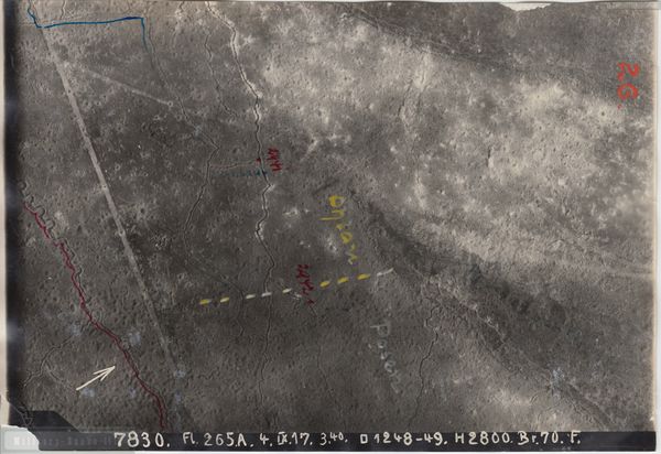
Aerial Photo Chemin de Dames La Royere Russennase
Map Section : 1349,1350
Flieger Abteilung : 265A
Date : 25.08.1917
Picture shows : Vincinity 1 km southsoutheast of Russennase/Russenschlucht
You'll get a high resolution scan of the aerial photo including a Google Earth KMZ locator file showing the position in Google Earth !
Click on picture to see location of photograph !
Sofort verfügbar
1,00€
Hinzufügen
Aerial Photo Chemin de Dames La Royere Russennase
Map Section : 1248,1348;1249;1349
Flieger Abteilung : 265A
Date : 22.09.1917
Picture shows : Vincinity 500 east of Ferme La Royere and Vincinity of Russennase
You'll get a high resolution scan of the aerial photo including a Google Earth KMZ locator file showing the position in Google Earth !
Click on picture to see location of photograph !
Sofort verfügbar
1,00€
Hinzufügen
Aerial Photo Chemin de Dames La Royere Russennase
Map Section : 1248,1249
Flieger Abteilung : 265A
Date : 04.09.1917
Picture shows : Vincinity 500 east of Ferme La Royere and Vincinity of Russennase
You'll get a high resolution scan of the aerial photo including a Google Earth KMZ locator file showing the position in Google Earth !
Click on picture to see location of photograph !
Sofort verfügbar
1,00€
Hinzufügen
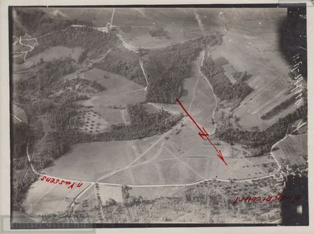
Aerial Photo Audignicourt
Map Section : n.a.
Flieger Abteilung : 11
Date : 09.07.1916
Picture shows : Vincinity east Audignicourt and road to Vassens
You'll get a high resolution scan of the aerial photo including a Google Earth KMZ locator file showing the position in Google Earth !
Click on picture to see location of photograph !
Sofort verfügbar
1,00€
Hinzufügen
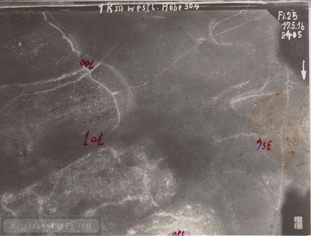
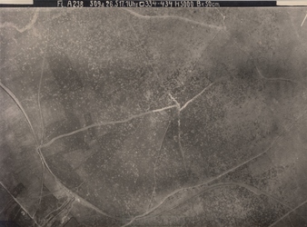
Aerial Photo Höhe 304
Map Section : 2405
Flieger Abteilung : 25
Date : 17.05.1916
Picture shows : Vincinity 1 km west of Höhe 304
You'll get a high resolution scan of the aerial photo including a Google Earth KMZ locator file showing the position in Google Earth !
Click on picture to see location of photograph !
Map Section : 2405
Flieger Abteilung : 25
Date : 17.05.1916
Picture shows : Vincinity 1 km west of Höhe 304
You'll get a high resolution scan of the aerial photo including a Google Earth KMZ locator file showing the position in Google Earth !
Click on picture to see location of photograph !
Sofort verfügbar
1,00€
Hinzufügen
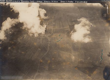
Aerial Photo Gentelles-Cachy
Map Section : 6008/6009
Flieger Abteilung : 269
Date : 06.04.1918
Picture shows : Vincinity around Gentelles-Cachy
You'll get a high resolution scan of the aerial photo including a Google Earth KMZ locator file showing the position in Google Earth !
Click on picture to see location of photograph !
Map Section : 6008/6009
Flieger Abteilung : 269
Date : 06.04.1918
Picture shows : Vincinity around Gentelles-Cachy
You'll get a high resolution scan of the aerial photo including a Google Earth KMZ locator file showing the position in Google Earth !
Click on picture to see location of photograph !
Sofort verfügbar
1,00€
Hinzufügen
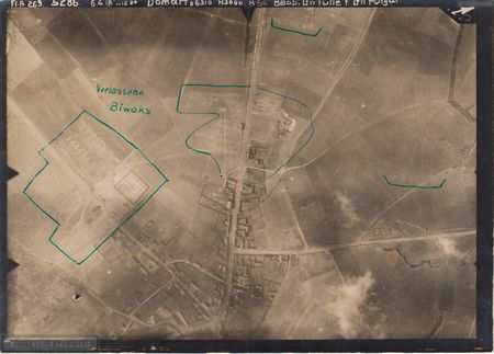
Aerial Photo Domart
Map Section : 6310
Flieger Abteilung : 269
Date : 06.04.1918
Picture shows : Domart west
You'll get a high resolution scan of the aerial photo including a Google Earth KMZ locator file showing the position in Google Earth !
Click on picture to see location of photograph !
Map Section : 6310
Flieger Abteilung : 269
Date : 06.04.1918
Picture shows : Domart west
You'll get a high resolution scan of the aerial photo including a Google Earth KMZ locator file showing the position in Google Earth !
Click on picture to see location of photograph !
Sofort verfügbar
1,00€
Hinzufügen
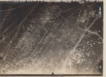
Aerial Photo Orainville Wald
Map Section : 310/311
Flieger Abteilung : 280
Date : 25.05.1917
Picture shows :
Area west of Orainville. In the past woods, now open fields. Compare IGN RLT AP 1960s for location
You'll get a high resolution scan of the aerial photo including a Google Earth KMZ locator file showing the position in Google Earth !
Click on picture to see location of photograph !
Sofort verfügbar
1,00€
Hinzufügen
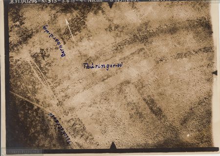
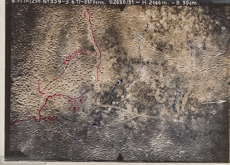
Aerial Photo Cornillet
Map Section : 1931/2031
Flieger Abteilung : 296
Date : 05.06.1917
Picture shows : Vincinity north of Cornillet
You'll get a high resolution scan of the aerial photo including a Google Earth KMZ locator file showing the position in Google Earth !
Click on picture to see location of photograph !
Map Section : 1931/2031
Flieger Abteilung : 296
Date : 05.06.1917
Picture shows : Vincinity north of Cornillet
You'll get a high resolution scan of the aerial photo including a Google Earth KMZ locator file showing the position in Google Earth !
Click on picture to see location of photograph !
Sofort verfügbar
1,00€
Hinzufügen
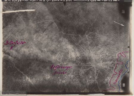
Aerial Photo Cornillet/Nauroy
Map Section : 1930/1931
Flieger Abteilung : 296
Date : 04.05.1917
Picture shows : Vincinity north of Cornillet
You'll get a high resolution scan of the aerial photo including a Google Earth KMZ locator file showing the position in Google Earth !
Click on picture to see location of photograph !
Map Section : 1930/1931
Flieger Abteilung : 296
Date : 04.05.1917
Picture shows : Vincinity north of Cornillet
You'll get a high resolution scan of the aerial photo including a Google Earth KMZ locator file showing the position in Google Earth !
Click on picture to see location of photograph !
Sofort verfügbar
1,00€
Hinzufügen
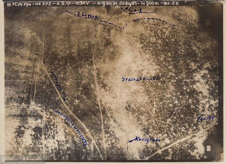
Aerial Photo Cornillet
Map Section : 2130
Flieger Abteilung : 296
Date : 14.06.1917
Picture shows : Vincinity south of Cornillet
You'll get a high resolution scan of the aerial photo including a Google Earth KMZ locator file showing the position in Google Earth !
Click on picture to see location of photograph !
Map Section : 2130
Flieger Abteilung : 296
Date : 14.06.1917
Picture shows : Vincinity south of Cornillet
You'll get a high resolution scan of the aerial photo including a Google Earth KMZ locator file showing the position in Google Earth !
Click on picture to see location of photograph !
Sofort verfügbar
1,00€
Hinzufügen
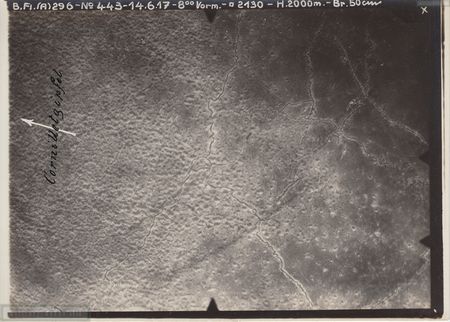
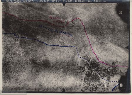
Aerial Photo Cornillet
Map Section : 2030/2131
Flieger Abteilung : 296
Date : 14.06.1917
Picture shows : Cornillet
You'll get a high resolution scan of the aerial photo including a Google Earth KMZ locator file showing the position in Google Earth !
Click on picture to see location of photograph !
Map Section : 2030/2131
Flieger Abteilung : 296
Date : 14.06.1917
Picture shows : Cornillet
You'll get a high resolution scan of the aerial photo including a Google Earth KMZ locator file showing the position in Google Earth !
Click on picture to see location of photograph !
Sofort verfügbar
1,00€
Hinzufügen
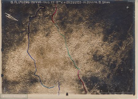
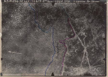
Aerial Photo Cornillet/Hexensattel
Map Section : 2031
Flieger Abteilung : 296
Date : 26.06.1917
Picture shows : Cornillet / Hexensattel
You'll get a high resolution scan of the aerial photo including a Google Earth KMZ locator file showing the position in Google Earth !
Click on picture to see location of photograph !
Map Section : 2031
Flieger Abteilung : 296
Date : 26.06.1917
Picture shows : Cornillet / Hexensattel
You'll get a high resolution scan of the aerial photo including a Google Earth KMZ locator file showing the position in Google Earth !
Click on picture to see location of photograph !
Sofort verfügbar
1,00€
Hinzufügen
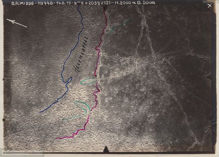
Aerial Photo Cornillet/Hexensattel
Map Section : 2031/2131
Flieger Abteilung : 296
Date : 14.06.1917
Picture shows : Cornillet / Hexensattel
You'll get a high resolution scan of the aerial photo including a Google Earth KMZ locator file showing the position in Google Earth !
Click on picture to see location of photograph !
Map Section : 2031/2131
Flieger Abteilung : 296
Date : 14.06.1917
Picture shows : Cornillet / Hexensattel
You'll get a high resolution scan of the aerial photo including a Google Earth KMZ locator file showing the position in Google Earth !
Click on picture to see location of photograph !
Sofort verfügbar
1,00€
Hinzufügen
Aerial Photo Cornillet/Hexensattel
Map Section : 2131
Flieger Abteilung : 296
Date : 14.06.1917
Picture shows : Vincinity south of Cornillet / Hexensattel
You'll get a high resolution scan of the aerial photo including a Google Earth KMZ locator file showing the position in Google Earth !
Click on picture to see location of photograph !
Sofort verfügbar
1,00€
Hinzufügen
Aerial Photo Cornillet/Hexensattel
Map Section : 2030
Flieger Abteilung : 296
Date : 03.06.1917
Picture shows : Cornillet / Hexensattel
You'll get a high resolution scan of the aerial photo including a Google Earth KMZ locator file showing the position in Google Earth !
Click on picture to see location of photograph !
Map Section : 2030
Flieger Abteilung : 296
Date : 03.06.1917
Picture shows : Cornillet / Hexensattel
You'll get a high resolution scan of the aerial photo including a Google Earth KMZ locator file showing the position in Google Earth !
Click on picture to see location of photograph !
Sofort verfügbar
1,00€
Hinzufügen
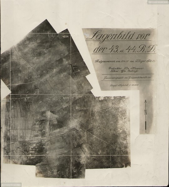
Aerial Photo Lagenbild Festubert West
Map Section : 4014,4114,4113
Flieger Abteilung : 255
Date : 21.04.1918
Picture shows :
Area west of Festubert, Festubert kann be seen on the right
You'll get a high resolution scan of the aerial photo including a Google Earth KMZ locator file showing the position in Google Earth !
Click on picture to see location of photograph !
Sofort verfügbar
5,00€
Hinzufügen
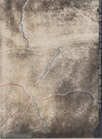
Aerial Photo Chaume Wald
Map Section : 1866
Flieger Abteilung : 291
Date : 01.10.1917
Picture shows :
Trenches in Chaume Wald , Trenches highlichted with color
You'll get a high resolution scan of the aerial photo including a Google Earth KMZ locator file showing the position in Google Earth !
Click on picture to see location of photograph !
Sofort verfügbar
1,50€
Hinzufügen
Aerial Photo Bezonvaux Nord
Map Section : 1968
Flieger Abteilung : 284
Date : 03.01.1918
Picture shows :
Area north of Bezonvaux , Trenches highlighted with color
You'll get a high resolution scan of the aerial photo including a Google Earth KMZ locator file showing the position in Google Earth !
Click on picture to see location of photograph !
Sofort verfügbar
1,00€
Hinzufügen
Aerial Photo Boreuilles
Map Section : -
Flieger Abteilung : -
Date : -
Picture shows :
Area north of Boreuilles , no picture header with map section or date
You'll get a high resolution scan of the aerial photo including a Google Earth KMZ locator file showing the position in Google Earth !
Click on picture to see location of photograph !
Sofort verfügbar
1,00€
Hinzufügen
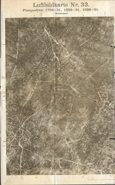
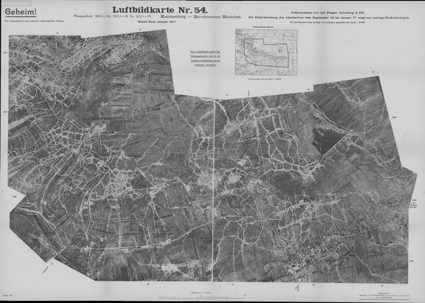
Aerial Photo Lagekarte Gueudecourt
Map Section : 1728-31 , 1828-31 , 1928-31
Flieger Abteilung : unknown
Date : unknown
Picture shows : Gueudecourt and vicinity , Area between Gueudecourt and Flers
You'll get a high resolution scan of the aerial photo including a Google Earth KMZ locator file showing the position in Google Earth !
Click on picture to see location of photograph !
Sofort verfügbar
6,00€
Hinzufügen

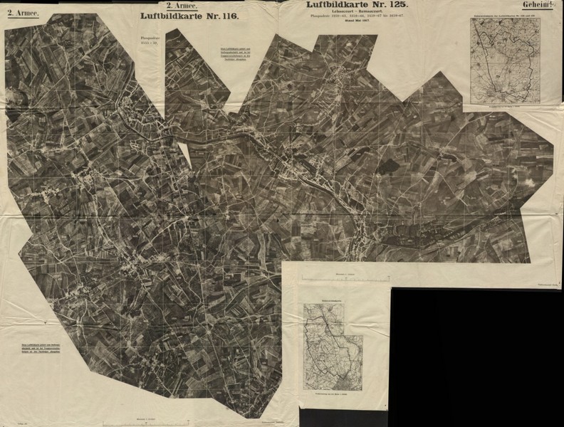
Aerial Photo Lagenbild Courcy
Map Section : 909-912;1009-1012 , parts of bordering sections
Flieger Abteilung : 286
Date : 16.05.1918
Picture shows : Courcy and surrounding vicinity
You'll get a high resolution scan of the aerial photo including a Google Earth KMZ locator file showing the position in Google Earth !
Click on picture to see location of photograph !
Sofort verfügbar
3,00€
Hinzufügen
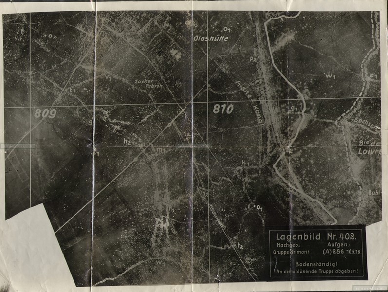
Aerial Photo Lagenbild Loivre
Map Section : 809,810 , parts of bordering sections north
Flieger Abteilung : 286
Date : 16.05.1918
Picture shows : Loivre and surrounding vicinity south
You'll get a high resolution scan of the aerial photo including a Google Earth KMZ locator file showing the position in Google Earth !
Click on picture to see location of photograph !
Sofort verfügbar
2,50€
Hinzufügen
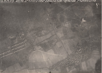
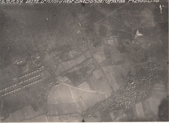
Aerial Photo Ostricourt Bais de L'Offlarde
Map Section : -
Flieger Abteilung : Feldflieger Abteilung Nr. 5
Date : 28.01.1918
Picture shows :
Area north west of Bois de L'Offlarde at Estricourt
You'll get a high resolution scan of the aerial photo including a Google Earth KMZ locator file showing the position in Google Earth !
Click on picture to see location of photograph !
Sofort verfügbar
1,00€
Hinzufügen
Aerial Photo Ecoust - Bullecourt
Map Section : 334-434
Flieger Abteilung : Feldflieger Abteilung Nr. 238
Date : 26.05.1917
Picture shows :
Area north east of Ecoulst directing to Bullecourt. Outskirts of Ecoust can be seen
You'll get a high resolution scan of the aerial photo including a Google Earth KMZ locator file showing the position in Google Earth !
Click on picture to see location of photograph !
Sofort verfügbar
1,00€
Hinzufügen
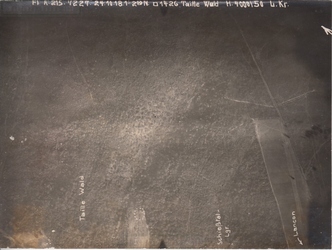
Aerial Photo Lancon Taille Wald
Map Section : 1426
Flieger Abteilung : FLA 215
Date : 24.10.1918
Picture shows :
Taille Wald area north of Lancon
You'll get a high resolution scan of the aerial photo including a Google Earth KMZ locator file showing the position in Google Earth !
Click on picture to see location of photograph !
Map Section : 1426
Flieger Abteilung : FLA 215
Date : 24.10.1918
Picture shows :
Taille Wald area north of Lancon
You'll get a high resolution scan of the aerial photo including a Google Earth KMZ locator file showing the position in Google Earth !
Click on picture to see location of photograph !
Sofort verfügbar
1,00€
Hinzufügen

Aerial Photo Exermont
Map Section : 1333/1433
Flieger Abteilung : FLA 295
Date : 04.10.1918
Picture shows :
Lager Neu Exermont south of Exermont
You'll get a high resolution scan of the aerial photo including a Google Earth KMZ locator file showing the position in Google Earth !
Click on picture to see location of photograph !
Sofort verfügbar
1,00€
Hinzufügen
Aerial Photo Ostricourt Bais de L'Offlarde
Map Section : -
Flieger Abteilung : Feldflieger Abteilung Nr. 5
Date : 28.01.1918
Picture shows :
Area north west of Bois de L'Offlarde at Estricourt
You'll get a high resolution scan of the aerial photo including a Google Earth KMZ locator file showing the position in Google Earth !
Click on picture to see location of photograph !
Map Section : -
Flieger Abteilung : Feldflieger Abteilung Nr. 5
Date : 28.01.1918
Picture shows :
Area north west of Bois de L'Offlarde at Estricourt
You'll get a high resolution scan of the aerial photo including a Google Earth KMZ locator file showing the position in Google Earth !
Click on picture to see location of photograph !
Sofort verfügbar
1,00€
Hinzufügen
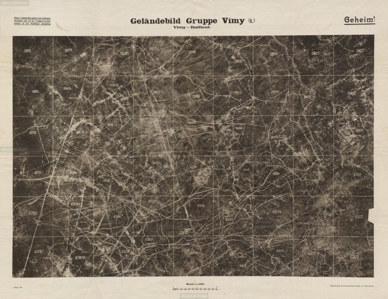
Aerial Photo Geländebild Vimy-Bailleul
Map Section : Square 5802 to 5810 to 6310 to 6302
Flieger Abteilung : unkown
Date : unknown
Picture shows : Area around Thelus , Farbus , Willerval , Vimy , Acheville , Arleux , Fresnoy , Oppy , Bauilleul
You'll get a high resolution scan of the aerial photo including a Google Earth KMZ locator file showing the position in Google Earth !
Click on picture to see location of photograph !
Sofort verfügbar
8,00€
Hinzufügen
Aerial Photo Luftbildkarte St. Quentin North Northwest
Map Section : 3155 to 3265 to 3467 to 3667 to 3661 to 4061 to 3957 to 3655
Flieger Abteilung : unkown
Date : Mai 1917
Picture shows : vicinity north and northwest St. Quentin Levergies to Bellenglise to Berthaucourt to Gricourt to Fresnoy-le-Petit to Fayet to St. Quentin to Remaucourt
You'll get a high resolution scan of the aerial photo including a Google Earth KMZ locator file showing the position in Google Earth !
Click on picture to see location of photograph !
Sofort verfügbar
8,00€
Hinzufügen
Aerial Photo Luftbildkarte Reims East
Map Section : 2125 to 2130 down to 2325 to 2330
Flieger Abteilung : FLA (A) 272
Date : March 1918
Picture shows : vicinity east of Reims along the old roman road (Alte Römer Straße) found at the southern part of the picture. you can see Les Marquises Ferme , Pestbeule , rote Häuse , Fasanenwald , Langer Rücken , Schwarzwald , Herrenwald and much more
You'll get a high resolution scan of the aerial photo including a Google Earth KMZ locator file showing the position in Google Earth !
Click on picture to see location of photograph !
Sofort verfügbar
8,00€
Hinzufügen
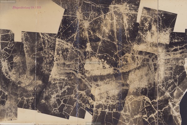
Aerial Photo Luftbildkarte Auberive East
Map Section : no PQs given
Flieger Abteilung : FLA (A) 251
Date : unknown
Picture shows : vicinity norhteast and east of Auberive (left part of the map) in the Suippes valley. The road to St. Souplet sur Py can be seen. northern limits of the map is half way to St. Souplet sur Py.
You'll get a high resolution scan of the aerial photo including a Google Earth KMZ locator file showing the position in Google Earth !
Click on picture to see location of photograph !
Sofort verfügbar
8,00€
Hinzufügen
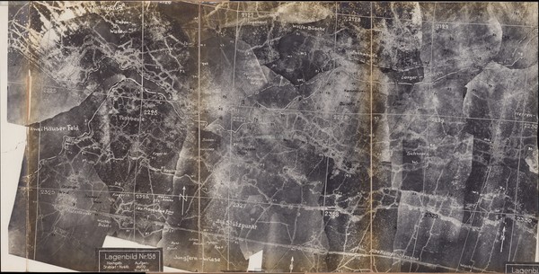
Aerial Photo Luftbildkarte Massiges / Kanonenberg
Map Section : 2215-2216 / 2315-2319 bis 2515-2519
Flieger Abteilung : FLA (A) 275
Date : End January 1917
Picture shows : vicinity from Kanonenberg to zerschossenen Häusschen and thus the complete Main des Massiges including Massiges village , Viile sur Tourbe , Etang de Ville
You'll get a high resolution scan of the aerial photo including a Google Earth KMZ locator file showing the position in Google Earth !
Click on picture to see location of photograph !
Sofort verfügbar
15,00€
Hinzufügen